| Name | Kleiner Trimm-Dich-Pfad (name)
|
| Type | highway:footway |
| Last Updated | 2018-12-05 15:41 |
| Admin Level | 15 |
| Rank | Minory Street / Path |
| Importance | 0.075 (estimated) |
| Coverage | Point |
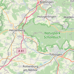
| Centre Point | 48.7564468,8.851628 |
| OSM | way 125108559 |
| Computed Postcode | 71263 |
| Address Tags | |
| Extra Tags | gravel (surface)
|
| Local name | Type | OSM | Address rank | Admin level | Distance | |
| Kleiner Trimm-Dich-Pfad | highway:footway | way 125108559 | 27 | 0 | details > | |
| Merklingen | boundary:administrative | relation 4832713 | 20 | 10 | 0 | details > |
| Weil der Stadt (Stadt) | boundary:administrative | relation 4832715 | 20 | 10 | 0 | details > |
| Weil der Stadt | place:town | relation 722152 | 16 | 8 | 0 | details > |
| Landkreis Böblingen | boundary:administrative | relation 62721 | 12 | 6 | 0 | details > |
| Regierungsbezirk Stuttgart | boundary:administrative | relation 22041 | 10 | 5 | 0 | details > |
| Baden-Württemberg | place:state | relation 62611 | 8 | 4 | 0 | details > |
| 71263 | place:postcode | 5 | 0 | |||
| 71263 | place:postcode | relation 3378979 | 5 | 0 | details > | |
| Deutschland | place:country | relation 51477 | 4 | 2 | ~3 m | details > |
| de | place:country_code | 4 | 0 | |||
Parent Of | ||||||
Bbq | ||||||
| Grillhütte | amenity:bbq | node 2381740824 | 30 | ~42 m | details > | |
Playground | ||||||
| ehem. Merklinger Sportplatz | leisure:playground | way 33288608 | 30 | ~5 m | details > | |
Picnic_site | ||||||
| No Name | tourism:picnic_site | node 2381740826 | 30 | ~40 m | details > | |