| Name | |
| Type | highway:unclassified |
| Last Updated | 2018-12-04 07:47 |
| Admin Level | 15 |
| Rank | Street / Major Landmark |
| Importance | 0.1 (estimated) |
| Coverage | Point |
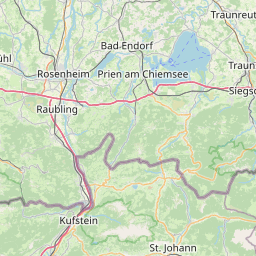
| Centre Point | 47.7416032,12.2090712 |
| OSM | way 142305740 |
| Computed Postcode | 83122 |
| Address Tags | |
| Extra Tags | 100 (maxspeed)
asphalt (surface)
|
| Local name | Type | OSM | Address rank | Admin level | Distance | |
| No Name | highway:unclassified | way 142305740 | 26 | 0 | details > | |
| Samerberg | place:village | relation 2186939 | 16 | 8 | 0 | details > |
| Oberstuff | place:hamlet | node 49927765 | 16 | 0 | details > | |
| Ried im Winkel | place:hamlet | node 1560440134 | 16 | 0 | details > | |
| Gerstland | place:hamlet | node 1557550163 | 16 | 0 | details > | |
| Brennbichl | place:hamlet | node 1557680256 | 16 | 0 | details > | |
| Gritschen | place:hamlet | node 1557550166 | 16 | 0 | details > | |
| Riedalm | place:hamlet | node 3518236365 | 16 | 0 | details > | |
| Schweibern | place:hamlet | node 1558649953 | 16 | 0 | details > | |
| Landkreis Rosenheim | place:county | relation 2156362 | 12 | 6 | 0 | details > |
| Obb | boundary:administrative | relation 2145274 | 10 | 5 | 0 | details > |
| Bayern | place:state | relation 2145268 | 8 | 4 | ~1 m | details > |
| 83122 | place:postcode | 5 | 0 | |||
| 83122 | place:postcode | relation 1114583 | 5 | 0 | details > | |
| Deutschland | place:country | relation 51477 | 4 | 2 | ~4 m | details > |
| de | place:country_code | 4 | 0 |