| Name | Neubolheim (name)
|
| Type | highway:service |
| Last Updated | 2018-12-05 14:50 |
| Admin Level | 15 |
| Rank | Minory Street / Path |
| Importance | 0.075 (estimated) |
| Coverage | Point |
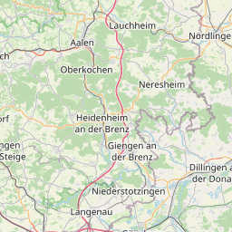
| Centre Point | 48.6406512,10.1551235 |
| OSM | way 161337585 |
| Computed Postcode | 89542 |
| Address Tags | |
| Extra Tags | asphalt (surface)
|
| Local name | Type | OSM | Address rank | Admin level | Distance | |
| Neubolheim | highway:service | way 161337585 | 27 | 0 | details > | |
| Neubolheim | landuse:industrial | way 38072170 | 22 | 0 | details > | |
| Bolheim | boundary:administrative | relation 2873834 | 20 | 10 | 0 | details > |
| Bolheim | boundary:administrative | relation 3008677 | 18 | 9 | 0 | details > |
| Herbrechtingen | place:town | relation 2791216 | 16 | 8 | 0 | details > |
| Bolheim | place:village | way 494830142 | 16 | 0 | details > | |
| Landkreis Heidenheim | boundary:administrative | relation 2812850 | 12 | 6 | 0 | details > |
| Regierungsbezirk Stuttgart | boundary:administrative | relation 22041 | 10 | 5 | 0 | details > |
| Baden-Württemberg | place:state | relation 62611 | 8 | 4 | ~1 m | details > |
| 89542 | place:postcode | 5 | 0 | |||
| 89542 | place:postcode | relation 1141136 | 5 | 0 | details > | |
| Deutschland | place:country | relation 51477 | 4 | 2 | ~3 m | details > |
| de | place:country_code | 4 | 0 | |||
Parent Of | ||||||
Wetland | ||||||
| Biberufer | natural:wetland | way 187786621 | 30 | ~114 m | details > | |
Building | ||||||
| Industrie Technische Dienstleistung GmbH | building:yes | way 161339781 | 30 | ~101 m | details > | |
| UGA | building:yes | way 160173213 | 30 | ~4 m | details > | |
| UGA | building:yes | way 161339785 | 30 | ~57 m | details > | |
Bicycle_parking | ||||||
| No Name | amenity:bicycle_parking | way 330286487 | 30 | ~25 m | details > | |