| Name | Strässle I (name)
|
| Type | landuse:industrial |
| Last Updated | 2018-12-03 20:44 |
| Admin Level | 15 |
| Rank | Croft / Farm / Locality / Islet |
| Importance | 0.2 (estimated) |
| Coverage | Polygon |
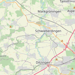
| Centre Point | 48.90134605,9.09575868855417 |
| OSM | way 203890493 |
| Computed Postcode | 71706 |
| Address Tags | |
| Extra Tags |
| Local name | Type | OSM | Address rank | Admin level | Distance | |
| Strässle I | landuse:industrial | way 203890493 | 22 | 0 | details > | |
| Ölmühle | place:isolated_dwelling | node 4081909743 | 20 | 0 | details > | |
| Markgröningen | place:town | relation 405841 | 16 | 8 | 0 | details > |
| Landkreis Ludwigsburg | boundary:administrative | relation 62536 | 12 | 6 | 0 | details > |
| Regierungsbezirk Stuttgart | boundary:administrative | relation 22041 | 10 | 5 | 0 | details > |
| Baden-Württemberg | place:state | relation 62611 | 8 | 4 | 0 | details > |
| 71706 | place:postcode | 5 | 0 | |||
| 71706 | place:postcode | relation 3364447 | 5 | 0 | details > | |
| Deutschland | place:country | relation 51477 | 4 | 2 | ~3 m | details > |
| de | place:country_code | 4 | 0 | |||
Parent Of | ||||||
Residential | ||||||
| Bahnhof | highway:residential | way 27252590 | 26 | ~278 m | details > | |
| Maulbronner Weg | highway:residential | way 26972269 | 26 | ~231 m | details > | |
| Maulbronner Weg | highway:residential | way 409129027 | 26 | ~212 m | details > | |
| Zeppelinstraße | highway:residential | way 515590852 | 26 | ~307 m | details > | |
Unclassified | ||||||
| Eckenerstraße | highway:unclassified | way 19794522 | 26 | ~329 m | details > | |
| Eckenerstraße | highway:unclassified | way 19794528 | 26 | ~358 m | details > | |
| Im Sträßle | highway:unclassified | way 26214262 | 26 | ~216 m | details > | |
| Im Sträßle | highway:unclassified | way 26965041 | 26 | ~46 m | details > | |
| Oberthstraße | highway:unclassified | way 26639495 | 26 | ~245 m | details > | |
| Schulze-Delitzsch-Straße | highway:unclassified | way 252953792 | 26 | ~308 m | details > | |
| Zeppelinstraße | highway:unclassified | way 28441808 | 26 | ~97 m | details > | |