| Name | L 1141 (ref)
|
| Type | highway:secondary |
| Last Updated | 2018-12-04 18:15 |
| Admin Level | 15 |
| Rank | Street / Major Landmark |
| Importance | 0.1 (estimated) |
| Coverage | Point |
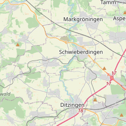
| Centre Point | 48.8928866,9.0889379 |
| OSM | way 232431814 |
| Computed Postcode | 71706 |
| Address Tags | |
| Extra Tags | asphalt (surface)
|
| Local name | Type | OSM | Address rank | Admin level | Distance | |
| L 1141 | highway:secondary | way 232431814 | 26 | 0 | details > | |
| Ölmühle | place:isolated_dwelling | node 4081909743 | 20 | 0 | details > | |
| Spitalmühle | place:isolated_dwelling | node 5404320196 | 20 | 0 | details > | |
| Neumühle | place:isolated_dwelling | node 1383251953 | 20 | 0 | details > | |
| Markgröningen | place:town | relation 405841 | 16 | 8 | 0 | details > |
| Landkreis Ludwigsburg | boundary:administrative | relation 62536 | 12 | 6 | 0 | details > |
| Regierungsbezirk Stuttgart | boundary:administrative | relation 22041 | 10 | 5 | 0 | details > |
| Baden-Württemberg | place:state | relation 62611 | 8 | 4 | 0 | details > |
| 71706 | place:postcode | 5 | 0 | |||
| 71706 | place:postcode | relation 3364447 | 5 | 0 | details > | |
| Deutschland | place:country | relation 51477 | 4 | 2 | ~3 m | details > |
| de | place:country_code | 4 | 0 | |||
Parent Of | ||||||
Street_cabinet | ||||||
| GPA 382 | man_made:street_cabinet | node 4266907703 | 30 | ~452 m | details > | |
| GPA 82 | man_made:street_cabinet | node 4266907709 | 30 | ~439 m | details > | |
Pitch | ||||||
| No Name | leisure:pitch | way 548829879 | 30 | ~89 m | details > | |
| No Name | leisure:pitch | way 97575415 | 30 | ~96 m | details > | |
Bridge | ||||||
| No Name | man_made:bridge | way 428636854 | 30 | ~431 m | details > | |