| Name | Schlifterweinberg (name)
|
| Type | highway:path |
| Last Updated | 2018-12-05 13:18 |
| Admin Level | 15 |
| Rank | Minory Street / Path |
| Importance | 0.075 (estimated) |
| Coverage | Point |
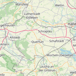
| Centre Point | 51.2114889,11.7751061 |
| OSM | way 240408343 |
| Computed Postcode | 06632 |
| Address Tags | |
| Extra Tags | yes (foot)
5 (maxspeed)
hiking (sac_scale)
ground (surface)
good (trail_visibility)
no (wheelchair)
1.0 (width)
|
| Local name | Type | OSM | Address rank | Admin level | Distance | |
| Schlifterweinberg | highway:path | way 240408343 | 27 | 0 | details > | |
| Nißmitz | place:suburb | node 415066145 | 20 | 0 | details > | |
| Freyburg (Unstrut) | boundary:administrative | relation 2403718 | 16 | 8 | 0 | details > |
| Freyburg | place:town | node 33314473 | 16 | 0 | details > | |
| Unstruttal | boundary:administrative | relation 2403778 | 14 | 7 | 0 | details > |
| Burgenlandkreis | place:county | relation 62639 | 12 | 6 | 0 | details > |
| Sachsen-Anhalt | place:state | relation 62607 | 8 | 4 | 0 | details > |
| 06632 | place:postcode | 5 | 0 | |||
| 06632 | place:postcode | relation 2405682 | 5 | 0 | details > | |
| Deutschland | place:country | relation 51477 | 4 | 2 | ~1 m | details > |
| de | place:country_code | 4 | 0 |