| Name | |
| Type | highway:unclassified |
| Last Updated | 2018-12-04 06:46 |
| Admin Level | 15 |
| Rank | Street / Major Landmark |
| Importance | 0.1 (estimated) |
| Coverage | Point |
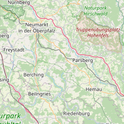
| Centre Point | 49.0241804,11.5425286 |
| OSM | way 246130217 |
| Computed Postcode | 92339 |
| Address Tags | |
| Extra Tags |
| Local name | Type | OSM | Address rank | Admin level | Distance | |
| No Name | highway:unclassified | way 246130217 | 26 | 0 | details > | |
| Eichelhof | place:suburb | node 339339811 | 20 | 0 | details > | |
| Beilngries | place:town | relation 943535 | 16 | 8 | 0 | details > |
| Pfenninghof | place:hamlet | node 1687334221 | 16 | 0 | details > | |
| Ottmaring | place:village | node 309155676 | 16 | 0 | details > | |
| Töging | place:village | node 339284769 | 16 | 0 | details > | |
| Grögling | place:village | node 346804731 | 16 | 0 | details > | |
| Kottingwörthermühle | place:hamlet | node 1687334223 | 16 | 0 | details > | |
| Kottingwörth | place:village | node 1598764817 | 16 | 0 | details > | |
| Dietfurt | place:town | relation 1028811 | 16 | 8 | 0 | details > |
| Landkreis Neumarkt in der Oberpfalz | boundary:administrative | relation 62620 | 12 | 6 | 0 | details > |
| Landkreis Eichstätt | boundary:administrative | relation 62684 | 12 | 6 | 0 | details > |
| OPf | boundary:administrative | relation 17596 | 10 | 5 | 0 | details > |
| Obb | boundary:administrative | relation 2145274 | 10 | 5 | 0 | details > |
| Bayern | place:state | relation 2145268 | 8 | 4 | 0 | details > |
| 92339 | place:postcode | 5 | 0 | |||
| 92345 | place:postcode | relation 1127319 | 5 | 0 | details > | |
| 92339 | place:postcode | relation 1127307 | 5 | 0 | details > | |
| Deutschland | place:country | relation 51477 | 4 | 2 | ~3 m | details > |
| de | place:country_code | 4 | 0 |