| Name | Crumbacher Straße (name)
Crumbacher Straße (name:de)
L 3203 (ref)
|
| Type | highway:secondary |
| Last Updated | 2018-12-04 12:54 |
| Admin Level | 15 |
| Rank | Street / Major Landmark |
| Importance | 0.1 (estimated) |
| Coverage | Point |
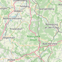
| Centre Point | 51.2716343,9.5372508 |
| OSM | way 301942589 |
| Computed Postcode | 34253 |
| Address Tags | |
| Extra Tags | 50 (maxspeed)
|
| Local name | Type | OSM | Address rank | Admin level | Distance | |
| Crumbacher Straße | highway:secondary | way 301942589 | 26 | 0 | details > | |
| Lohfelden | place:town | relation 1115032 | 16 | 8 | 0 | details > |
| Crumbach | place:village | node 423774198 | 16 | 0 | details > | |
| Landkreis Kassel | place:county | relation 62401 | 12 | 6 | 0 | details > |
| Regierungsbezirk Kassel | boundary:administrative | relation 286675 | 10 | 5 | 0 | details > |
| Hessen | place:state | relation 62650 | 8 | 4 | 0 | details > |
| 34253 | place:postcode | 5 | 0 | |||
| 34253 | place:postcode | relation 3356553 | 5 | 0 | details > | |
| Deutschland | place:country | relation 51477 | 4 | 2 | 0 | details > |
| de | place:country_code | 4 | 0 | |||
| Europe | place:continent | node 25871341 | 2 | 0 | details > | |
Parent Of | ||||||
Building | ||||||
| No Name | building:yes | way 302051868 | 30 | ~13 m | details > | |
| No Name | building:yes | way 302051869 | 30 | ~17 m | details > | |
| No Name | building:yes | way 302051870 | 30 | ~12 m | details > | |
| No Name | building:yes | way 302051865 | 30 | ~34 m | details > | |
| No Name | building:yes | way 302051866 | 30 | ~23 m | details > | |
Street_lamp | ||||||
| No Name | highway:street_lamp | node 3063101703 | 30 | ~5 m | details > | |