| Name | Kammerweg (name)
|
| Type | highway:track |
| Last Updated | 2018-12-04 13:49 |
| Admin Level | 15 |
| Rank | Street / Major Landmark |
| Importance | 0.1 (estimated) |
| Coverage | Point |
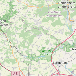
| Centre Point | 48.592293,10.1221675 |
| OSM | way 384317363 |
| Computed Postcode | 89547 |
| Address Tags | |
| Extra Tags | no (access)
yes (foot)
grade1 (tracktype)
|
| Local name | Type | OSM | Address rank | Admin level | Distance | |
| Kammerweg | highway:track | way 384317363 | 26 | 0 | details > | |
| Mittlere Häuäcker | place:isolated_dwelling | node 3929639273 | 20 | 0 | details > | |
| Gemarkung Dettingen am Albuch | boundary:administrative | relation 3653447 | 18 | 9 | 0 | details > |
| Gerstetten | place:village | relation 2772184 | 16 | 8 | 0 | details > |
| Anhausen | place:village | node 274717699 | 16 | 0 | details > | |
| Dettingen am Albuch | place:village | node 272871722 | 16 | 0 | details > | |
| Heuchlingen | place:village | node 272871724 | 16 | 0 | details > | |
| Hausen ob Lontal | place:village | node 344920330 | 16 | 0 | details > | |
| Landkreis Heidenheim | boundary:administrative | relation 2812850 | 12 | 6 | 0 | details > |
| Regierungsbezirk Stuttgart | boundary:administrative | relation 22041 | 10 | 5 | 0 | details > |
| Baden-Württemberg | place:state | relation 62611 | 8 | 4 | ~1 m | details > |
| 89547 | place:postcode | 5 | 0 | |||
| 89547 | place:postcode | relation 1141141 | 5 | 0 | details > | |
| Deutschland | place:country | relation 51477 | 4 | 2 | ~3 m | details > |
| de | place:country_code | 4 | 0 | |||
Parent Of | ||||||
Building | ||||||
| No Name | building:yes | way 383589330 | 30 | ~26 m | details > | |
Parking | ||||||
| No Name | amenity:parking | way 383589333 | 30 | ~79 m | details > | |