| Name | Kirchenstraße (name)
|
| Type | highway:footway |
| Last Updated | 2018-12-05 14:09 |
| Admin Level | 15 |
| Rank | Minory Street / Path |
| Importance | 0.075 (estimated) |
| Coverage | Point |
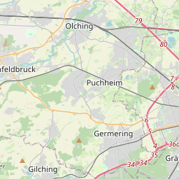
| Centre Point | 48.1950304,11.3727911 |
| OSM | way 392752053 |
| Computed Postcode | 82194 |
| Address Tags | |
| Extra Tags | asphalt (surface)
grade1 (tracktype)
|
| Local name | Type | OSM | Address rank | Admin level | Distance | |
| Kirchenstraße | highway:footway | way 392752053 | 27 | 0 | details > | |
| Puchheim-Bahnhof | place:suburb | node 51571782 | 20 | 0 | details > | |
| Graßlfing | place:suburb | node 1823288022 | 20 | 0 | details > | |
| Lochhausen | place:suburb | node 269702375 | 20 | 0 | details > | |
| Gröbenzell | place:village | relation 933494 | 16 | 8 | 0 | details > |
| Landkreis Fürstenfeldbruck | boundary:administrative | relation 62595 | 12 | 6 | 0 | details > |
| Obb | boundary:administrative | relation 2145274 | 10 | 5 | 0 | details > |
| Bayern | place:state | relation 2145268 | 8 | 4 | 0 | details > |
| 82194 | place:postcode | 5 | 0 | |||
| 82194 | place:postcode | relation 1104811 | 5 | 0 | details > | |
| Deutschland | place:country | relation 51477 | 4 | 2 | ~3 m | details > |
| de | place:country_code | 4 | 0 | |||
Parent Of | ||||||
Bakery | ||||||
| No Name | shop:bakery | node 5061579027 | 30 | ~17 m | details > | |