| Name | |
| Type | highway:unclassified |
| Last Updated | 2018-12-04 02:40 |
| Admin Level | 15 |
| Rank | Street / Major Landmark |
| Importance | 0.1 (estimated) |
| Coverage | Point |
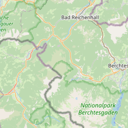
| Centre Point | 47.6731865,12.8257872 |
| OSM | way 420340171 |
| Computed Postcode | 83458 |
| Address Tags | |
| Extra Tags | no (oneway)
asphalt (surface)
|
| Local name | Type | OSM | Address rank | Admin level | Distance | |
| No Name | highway:unclassified | way 420340171 | 26 | 0 | details > | |
| Schneizlreuth | place:village | relation 941796 | 16 | 8 | 0 | details > |
| Unterjettenberg | place:village | node 78541672 | 16 | 0 | details > | |
| Landkreis Berchtesgadener Land | boundary:administrative | relation 62712 | 12 | 6 | 0 | details > |
| Obb | boundary:administrative | relation 2145274 | 10 | 5 | ~1 m | details > |
| Bayern | place:state | relation 2145268 | 8 | 4 | ~2 m | details > |
| 83458 | place:postcode | 5 | 0 | |||
| 83458 | place:postcode | relation 1114654 | 5 | 0 | details > | |
| Deutschland | place:country | relation 51477 | 4 | 2 | ~4 m | details > |
| de | place:country_code | 4 | 0 |