| Name | B 180 (ref)
|
| Type | highway:primary |
| Last Updated | 2018-12-04 04:35 |
| Admin Level | 15 |
| Rank | Street / Major Landmark |
| Importance | 0.1 (estimated) |
| Coverage | Point |
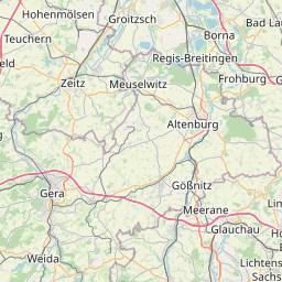
| Centre Point | 51.03379,12.228963 |
| OSM | way 546828336 |
| Computed Postcode | 06712 |
| Address Tags | |
| Extra Tags | 100 (maxspeed)
asphalt (surface)
|
| Local name | Type | OSM | Address rank | Admin level | Distance | |
| B 180 | highway:primary | way 546828336 | 26 | 0 | details > | |
| Würchwitz | boundary:administrative | relation 2404867 | 20 | 10 | 0 | details > |
| Zeitz | place:town | relation 2404586 | 16 | 8 | 0 | details > |
| Oelsen | place:village | node 2095249206 | 16 | 0 | details > | |
| Bockwitz | place:village | node 2095292537 | 16 | 0 | details > | |
| Suxdorf | place:village | node 2035711433 | 16 | 0 | details > | |
| Würchwitz | place:village | node 240072783 | 16 | 0 | details > | |
| Lobas | place:village | node 435473719 | 16 | 0 | details > | |
| Rehmsdorf | place:village | node 240096214 | 16 | 0 | details > | |
| Kadischen | place:hamlet | node 2095249211 | 16 | 0 | details > | |
| Loitsch | place:village | node 2095185053 | 16 | 0 | details > | |
| Sprossen | place:village | node 1756917105 | 16 | 0 | details > | |
| Burgenlandkreis | place:county | relation 62639 | 12 | 6 | 0 | details > |
| Sachsen-Anhalt | place:state | relation 62607 | 8 | 4 | ~1 m | details > |
| 06712 | place:postcode | 5 | 0 | |||
| 06712 | place:postcode | relation 2405004 | 5 | 0 | details > | |
| Deutschland | place:country | relation 51477 | 4 | 2 | ~2 m | details > |
| de | place:country_code | 4 | 0 | |||
Parent Of | ||||||
Runway | ||||||
| No Name | aeroway:runway | way 59990797 | 30 | ~1 km | details > | |