| Name | Herrenkrug (name)
|
| Type | boundary:administrative |
| Last Updated | 2018-12-03 18:28 |
| Admin Level | 10 |
| Rank | Suburb |
| Importance | 0.25 (estimated) |
| Coverage | Polygon |
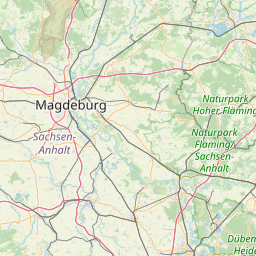
| Centre Point | 52.1480633,11.6820911 |
| OSM | relation 78823 |
| Computed Postcode | |
| Address Tags | |
| Extra Tags | suburb (place)
Q1614118 (wikidata)
de:Herrenkrug (wikipedia)
|
| Local name | Type | OSM | Address rank | Admin level | Distance | |
| Herrenkrug | boundary:administrative | relation 78823 | 20 | 10 | 0 | details > |
| Magdeburg | place:city | relation 62481 | 12 | 6 | 0 | details > |
| Sachsen-Anhalt | place:state | relation 62607 | 8 | 4 | 0 | details > |
| Deutschland | place:country | relation 51477 | 4 | 2 | ~2 m | details > |
| de | place:country_code | 4 | 0 | |||
Linked Places | ||||||
| Herrenkrug | place:suburb | node 272384658 | 20 | 0 | details > | |
Parent Of | ||||||
Forest | ||||||
| Biederitzer Busch | landuse:forest | way 583001700 | 0 | ~486 m | details > | |
| Biederitzer Busch | landuse:forest | relation 8239803 | 0 | ~787 m | details > | |
Meadow | ||||||
| Große Angerwiese | landuse:meadow | way 424524878 | 0 | ~1.1 km | details > | |
Landfill | ||||||
| Mülldeponie Cracauer Anger (geschlossen) | landuse:landfill | way 30054712 | 0 | ~1.2 km | details > | |
Administrative | ||||||
| Cracauer Anger | boundary:administrative | relation 5929423 | 22 | 11 | ~402 m | details > |
| Herrenkrug/Biederitzer Busch | boundary:administrative | relation 5929424 | 22 | 11 | ~402 m | details > |
Industrial | ||||||
| Trinkwasserversorgung Magdeburg GmbH | landuse:industrial | way 171204690 | 22 | ~907 m | details > | |