| Name | Beyendorf-Sohlen (name)
|
| Type | boundary:administrative |
| Last Updated | 2018-12-03 17:23 |
| Admin Level | 9 |
| Rank | Village / Hamlet |
| Importance | 0.3 (estimated) |
| Coverage | Polygon |
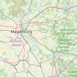
| Centre Point | 52.0520144,11.6370365 |
| OSM | relation 79021 |
| Computed Postcode | |
| Address Tags | |
| Extra Tags | suburb (place)
Q631858 (wikidata)
de:Beyendorf-Sohlen (wikipedia)
|
| Local name | Type | OSM | Address rank | Admin level | Distance | |
| Beyendorf-Sohlen | boundary:administrative | relation 79021 | 18 | 9 | 0 | details > |
| Magdeburg | place:city | relation 62481 | 12 | 6 | 0 | details > |
| Sachsen-Anhalt | place:state | relation 62607 | 8 | 4 | 0 | details > |
| Deutschland | place:country | relation 51477 | 4 | 2 | ~1 m | details > |
| de | place:country_code | 4 | 0 | |||
Linked Places | ||||||
| Beyendorf-Sohlen | place:suburb | node 301462059 | 20 | 0 | details > | |
Parent Of | ||||||
Locality | ||||||
| Rote Mühle | place:locality | node 299441767 | 0 | ~1.3 km | details > | |
| Zum Engel | place:locality | node 319950754 | 0 | ~2.3 km | details > | |
Cemetery | ||||||
| Friedhof Beyendorf | landuse:cemetery | way 27280592 | 0 | ~1 km | details > | |
| Friedhof Sohlen | landuse:cemetery | way 27811849 | 0 | ~638 m | details > | |
Quarry | ||||||
| Kiesgrube | landuse:quarry | way 26842321 | 0 | ~1.4 km | details > | |
Hamlet | ||||||
| Anker | place:hamlet | node 294796113 | 16 | ~1.7 km | details > | |
Village | ||||||
| Beyendorf | place:village | node 86040525 | 16 | ~624 m | details > | |
| Sohlen | place:village | node 86040949 | 16 | ~561 m | details > | |
Allotments | ||||||
| An der Mühle | landuse:allotments | way 27281242 | 22 | ~750 m | details > | |
| An der Mühle | landuse:allotments | way 27811268 | 22 | ~692 m | details > | |
Administrative | ||||||
| Beyendorf | boundary:administrative | relation 5932373 | 22 | 11 | ~36 m | details > |
| Sohlen | boundary:administrative | relation 5932374 | 22 | 11 | ~82 m | details > |
Residential | ||||||
| Froschgrund | landuse:residential | way 27811390 | 22 | ~336 m | details > | |
Farmyard | ||||||
| Gärtnerei | landuse:farmyard | way 26842266 | 22 | ~1.7 km | details > | |