| Name | Sülzegrund (name)
|
| Type | boundary:administrative |
| Last Updated | 2018-12-03 18:28 |
| Admin Level | 10 |
| Rank | Suburb |
| Importance | 0.25 (estimated) |
| Coverage | Polygon |
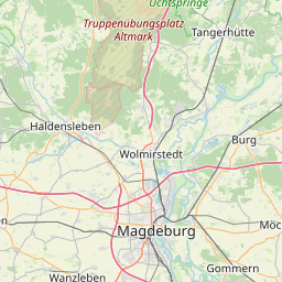
| Centre Point | 52.1783017,11.6156084 |
| OSM | relation 79527 |
| Computed Postcode | |
| Address Tags | |
| Extra Tags | suburb (place)
Q974584 (wikidata)
de:Sülzegrund (wikipedia)
|
| Local name | Type | OSM | Address rank | Admin level | Distance | |
| Sülzegrund | boundary:administrative | relation 79527 | 20 | 10 | 0 | details > |
| Ebendorf | place:village | node 36427641 | 16 | 0 | details > | |
| Magdeburg | place:city | relation 62481 | 12 | 6 | 0 | details > |
| Sachsen-Anhalt | place:state | relation 62607 | 8 | 4 | 0 | details > |
| Deutschland | place:country | relation 51477 | 4 | 2 | ~2 m | details > |
| de | place:country_code | 4 | 0 | |||
Linked Places | ||||||
| Sülzegrund | place:suburb | node 281013074 | 20 | 0 | details > | |
Parent Of | ||||||
Retail | ||||||
| Am Pfahlberg | landuse:retail | way 9795754 | 22 | ~139 m | details > | |
| IKEA | landuse:retail | way 31876817 | 22 | ~954 m | details > | |
Administrative | ||||||
| Milchhof | boundary:administrative | relation 5887567 | 22 | 11 | ~789 m | details > |
| Sülzegrund Nord | boundary:administrative | relation 5887568 | 22 | 11 | ~251 m | details > |
Commercial | ||||||
| Wareneingang | landuse:commercial | way 519058867 | 22 | ~974 m | details > | |