| Name | Kappel (name)
|
| Type | boundary:administrative |
| Last Updated | 2018-12-03 17:36 |
| Admin Level | 9 |
| Rank | Village / Hamlet |
| Importance | 0.3 (estimated) |
| Coverage | Polygon |
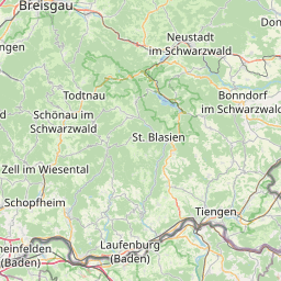
| Centre Point | 47.877097,8.24001962580047 |
| OSM | relation 324409 |
| Computed Postcode | |
| Address Tags | |
| Extra Tags | Q1668217 (wikidata)
de:Kappel (Lenzkirch) (wikipedia)
|
| Local name | Type | OSM | Address rank | Admin level | Distance | |
| Kappel | boundary:administrative | relation 324409 | 18 | 9 | 0 | details > |
| Lenzkirch | place:town | relation 317630 | 16 | 8 | 0 | details > |
| Landkreis Breisgau-Hochschwarzwald | boundary:administrative | relation 1946367 | 12 | 6 | 0 | details > |
| Regierungsbezirk Freiburg | boundary:administrative | relation 2106112 | 10 | 5 | 0 | details > |
| Baden-Württemberg | place:state | relation 62611 | 8 | 4 | ~1 m | details > |
| Deutschland | place:country | relation 51477 | 4 | 2 | ~4 m | details > |
| de | place:country_code | 4 | 0 | |||
Parent Of | ||||||
Locality | ||||||
| Rauhalde | place:locality | way 126034083 | 0 | ~1.4 km | details > | |
Village | ||||||
| Kappel | place:village | node 201035501 | 16 | ~720 m | details > | |
Hamlet | ||||||
| Kappel-Gutachbrücke | place:hamlet | way 84297226 | 16 | ~1.1 km | details > | |
Isolated_dwelling | ||||||
| Junghof | place:isolated_dwelling | node 2311678676 | 20 | ~629 m | details > | |
| Zipfelsäge | place:isolated_dwelling | way 482078788 | 20 | ~882 m | details > | |
Track | ||||||
| Lehenweg | highway:track | way 54535805 | 26 | ~1.4 km | details > | |
| Schleifhaldenweg | highway:track | way 71432803 | 26 | ~1.8 km | details > | |
Path | ||||||
| Rettungssektor A | highway:path | way 161528700 | 27 | ~2.4 km | details > | |
| Rettungssektor A | highway:path | way 161528703 | 27 | ~2.4 km | details > | |
| Rettungssektor A | highway:path | way 161528706 | 27 | ~2.5 km | details > | |
| Rettungssektor A | highway:path | way 311972196 | 27 | ~2.3 km | details > | |
| Rettungssektor A | highway:path | way 161528695 | 27 | ~2.4 km | details > | |
| Rettungssektor C | highway:path | way 34127427 | 27 | ~2.4 km | details > | |