| Name | Nutha (name)
|
| Type | boundary:administrative |
| Last Updated | 2018-12-03 17:23 |
| Admin Level | 9 |
| Rank | Village / Hamlet |
| Importance | 0.3 (estimated) |
| Coverage | Polygon |
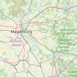
| Centre Point | 51.96097265,12.0290965394007 |
| OSM | relation 2260654 |
| Computed Postcode | |
| Address Tags | |
| Extra Tags | Q690013 (wikidata)
de:Nutha (wikipedia)
|
| Local name | Type | OSM | Address rank | Admin level | Distance | |
| Nutha | boundary:administrative | relation 2260654 | 18 | 9 | 0 | details > |
| Zerbst/Anhalt | boundary:administrative | relation 1070782 | 16 | 8 | 0 | details > |
| Anhalt-Bitterfeld | boundary:administrative | relation 62747 | 12 | 6 | 0 | details > |
| Sachsen-Anhalt | place:state | relation 62607 | 8 | 4 | 0 | details > |
| Deutschland | place:country | relation 51477 | 4 | 2 | ~2 m | details > |
| de | place:country_code | 4 | 0 | |||
Parent Of | ||||||
Hamlet | ||||||
| Amtsmühle | place:hamlet | node 5848372898 | 16 | ~2 km | details > | |
| Nuthasche Mühle | place:hamlet | node 5848443082 | 16 | ~637 m | details > | |
| Wiesenmühle | place:hamlet | node 5848372924 | 16 | ~700 m | details > | |
| No Name | place:hamlet | way 635428867 | 16 | ~51 m | details > | |
Suburb | ||||||
| Niederlepte | place:suburb | node 447003547 | 20 | ~66 m | details > | |
| Nutha | place:suburb | node 240023524 | 20 | ~1.2 km | details > | |
| Nutha-Siedlung | place:suburb | node 447003548 | 20 | ~3 km | details > | |