| Name | Thundorf (name)
|
| Type | highway:service |
| Last Updated | 2018-12-05 13:06 |
| Admin Level | 15 |
| Rank | Minory Street / Path |
| Importance | 0.075 (estimated) |
| Coverage | Point |
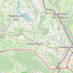
| Centre Point | 47.820573,12.9053287 |
| OSM | way 25587410 |
| Computed Postcode | 83404 |
| Address Tags | |
| Extra Tags | 1 (lanes)
driveway (service)
|
| Local name | Type | OSM | Address rank | Admin level | Distance | |
| Thundorf | highway:service | way 25587410 | 27 | 0 | details > | |
| Gschwendt | place:isolated_dwelling | node 3635425897 | 20 | 0 | details > | |
| Ainring | place:village | relation 941761 | 16 | 8 | 0 | details > |
| Oberholzen | place:hamlet | node 312636650 | 16 | 0 | details > | |
| Bach | place:hamlet | node 280459198 | 16 | 0 | details > | |
| Hinterau | place:hamlet | node 312544080 | 16 | 0 | details > | |
| Thundorf | place:village | node 278952991 | 16 | 0 | details > | |
| Thundorfer Mühle | place:hamlet | node 279336260 | 16 | 0 | details > | |
| Landkreis Berchtesgadener Land | boundary:administrative | relation 62712 | 12 | 6 | 0 | details > |
| Obb | boundary:administrative | relation 2145274 | 10 | 5 | ~1 m | details > |
| Bayern | place:state | relation 2145268 | 8 | 4 | ~2 m | details > |
| 83404 | place:postcode | 5 | 0 | |||
| 83404 | place:postcode | relation 1114642 | 5 | 0 | details > | |
| Deutschland | place:country | relation 51477 | 4 | 2 | ~4 m | details > |
| de | place:country_code | 4 | 0 | |||
Parent Of | ||||||
Car | ||||||
| Fiat Enzinger | shop:car | way 164422461 | 30 | ~32 m | details > | |
Agricultural_engines | ||||||
| Landmaschinen Enzinger | craft:agricultural_engines | way 164422464 | 30 | ~49 m | details > | |
Building | ||||||
| No Name | building:yes | way 164422459 | 30 | ~16 m | details > | |
| No Name | building:yes | way 165329774 | 30 | ~209 m | details > | |