| Name | |
| Type | highway:unclassified |
| Last Updated | 2018-12-05 03:18 |
| Admin Level | 15 |
| Rank | Street / Major Landmark |
| Importance | 0.1 (estimated) |
| Coverage | Point |
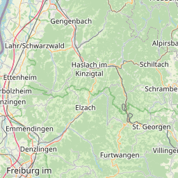
| Centre Point | 48.2348653,8.293826 |
| OSM | way 43798150 |
| Computed Postcode | 78730 |
| Address Tags | |
| Extra Tags | 30 (maxspeed)
|
| Local name | Type | OSM | Address rank | Admin level | Distance | |
| No Name | highway:unclassified | way 43798150 | 26 | 0 | details > | |
| Langwieserhof | place:isolated_dwelling | node 3463776609 | 20 | 0 | details > | |
| Lauterbach | place:village | relation 943742 | 16 | 8 | 0 | details > |
| Fohrenbühl | place:hamlet | node 3473441484 | 16 | 0 | details > | |
| Hugenhof | place:hamlet | node 5451339156 | 16 | 0 | details > | |
| Mooswald | place:hamlet | node 3634952421 | 16 | 0 | details > | |
| Hornberg | place:town | relation 453006 | 16 | 8 | 0 | details > |
| Verwaltungsgemeinschaft Schramberg | boundary:administrative | relation 2958049 | 14 | 7 | 0 | details > |
| Landkreis Rottweil | boundary:administrative | relation 62344 | 12 | 6 | 0 | details > |
| Ortenaukreis | place:county | relation 62624 | 12 | 6 | 0 | details > |
| Regierungsbezirk Freiburg | boundary:administrative | relation 2106112 | 10 | 5 | 0 | details > |
| Baden-Württemberg | place:state | relation 62611 | 8 | 4 | 0 | details > |
| 78730 | place:postcode | 5 | 0 | |||
| 78132 | place:postcode | relation 3375458 | 5 | 0 | details > | |
| 78730 | place:postcode | relation 3375459 | 5 | 0 | details > | |
| Deutschland | place:country | relation 51477 | 4 | 2 | ~4 m | details > |
| de | place:country_code | 4 | 0 |