| Name | Fallerstraße (name)
|
| Type | highway:service |
| Last Updated | 2018-12-05 14:14 |
| Admin Level | 15 |
| Rank | Minory Street / Path |
| Importance | 0.075 (estimated) |
| Coverage | Point |
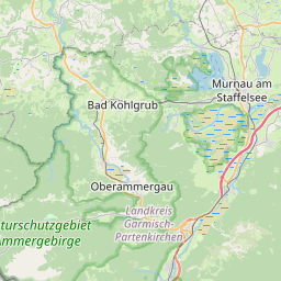
| Centre Point | 47.661242,11.0505305 |
| OSM | way 50761053 |
| Computed Postcode | 82433 |
| Address Tags | |
| Extra Tags |
| Local name | Type | OSM | Address rank | Admin level | Distance | |
| Fallerstraße | highway:service | way 50761053 | 27 | 0 | details > | |
| Kappellaine | place:isolated_dwelling | node 5431995722 | 20 | 0 | details > | |
| Schönau | place:isolated_dwelling | node 5527158483 | 20 | 0 | details > | |
| Bad Kohlgrub | place:town | relation 937894 | 16 | 8 | 0 | details > |
| Sonnen | place:hamlet | node 1724649548 | 16 | 0 | details > | |
| Schönau | place:hamlet | node 1724649547 | 16 | 0 | details > | |
| Gagers | place:village | node 1700556857 | 16 | 0 | details > | |
| Guggenberg | place:hamlet | node 1724649353 | 16 | 0 | details > | |
| Linden | place:village | node 1724649422 | 16 | 0 | details > | |
| Obernau | place:hamlet | node 1724649473 | 16 | 0 | details > | |
| Landkreis Garmisch-Partenkirchen | boundary:administrative | relation 62726 | 12 | 6 | 0 | details > |
| Obb | boundary:administrative | relation 2145274 | 10 | 5 | 0 | details > |
| Bayern | place:state | relation 2145268 | 8 | 4 | ~1 m | details > |
| 82433 | place:postcode | 5 | 0 | |||
| 82433 | place:postcode | relation 1109071 | 5 | 0 | details > | |
| Deutschland | place:country | relation 51477 | 4 | 2 | ~4 m | details > |
| de | place:country_code | 4 | 0 | |||
Parent Of | ||||||
Building | ||||||
| Jagakloßhof | building:yes | way 142679740 | 30 | ~28 m | details > | |
Blacksmith | ||||||
| Landmaschinen Josef Mangold | craft:blacksmith | way 560993452 | 30 | ~22 m | details > | |