| Name | Höhenring (name)
|
| Type | highway:residential |
| Last Updated | 2018-12-04 17:32 |
| Admin Level | 15 |
| Rank | Street / Major Landmark |
| Importance | 0.1 (estimated) |
| Coverage | Point |
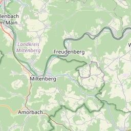
| Centre Point | 49.713058,9.3582598 |
| OSM | way 54891028 |
| Computed Postcode | 97896 |
| Address Tags | |
| Extra Tags | 50 (maxspeed)
asphalt (surface)
|
| Local name | Type | OSM | Address rank | Admin level | Distance | |
| Höhenring | highway:residential | way 54891028 | 26 | 0 | details > | |
| Ebenheiderhof | place:isolated_dwelling | node 3770319887 | 20 | 0 | details > | |
| Freudenberg | place:town | relation 401777 | 16 | 8 | 0 | details > |
| Ebenheid | place:village | node 148164166 | 16 | 0 | details > | |
| Main-Tauber-Kreis | place:county | relation 62542 | 12 | 6 | 0 | details > |
| Regierungsbezirk Stuttgart | boundary:administrative | relation 22041 | 10 | 5 | 0 | details > |
| Baden-Württemberg | place:state | relation 62611 | 8 | 4 | ~1 m | details > |
| 97896 | place:postcode | 5 | 0 | |||
| 97896 | place:postcode | relation 1178640 | 5 | 0 | details > | |
| Deutschland | place:country | relation 51477 | 4 | 2 | ~2 m | details > |
| de | place:country_code | 4 | 0 | |||
Parent Of | ||||||
House | ||||||
| No Name | place:house | node 4774187985 | 30 | ~16 m | details > | |