| Name | Wolfratshauser Straße (name)
Wolfratshauser Straße (name:de)
St 2073 (ref)
|
| Type | highway:secondary |
| Last Updated | 2018-12-04 07:52 |
| Admin Level | 15 |
| Rank | Street / Major Landmark |
| Importance | 0.1 (estimated) |
| Coverage | Point |
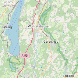
| Centre Point | 47.8652301,11.5432965 |
| OSM | way 60090444 |
| Computed Postcode | 83623 |
| Address Tags | |
| Extra Tags | 50 (maxspeed)
good (smoothness)
asphalt (surface)
|
| Local name | Type | OSM | Address rank | Admin level | Distance | |
| Wolfratshauser Straße | highway:secondary | way 60090444 | 26 | 0 | details > | |
| Golkofen | place:isolated_dwelling | node 260626841 | 20 | 0 | details > | |
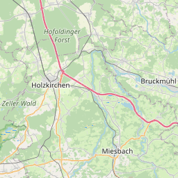
| Dietramszell | place:village | relation 935150 | 16 | 8 | 0 | details > |
| Großeglsee | place:hamlet | node 257423880 | 16 | 0 | details > | |
| Kleineglsee | place:hamlet | node 64633973 | 16 | 0 | details > | |
| Stockach | place:hamlet | node 433989663 | 16 | 0 | details > | |
| Podling | place:hamlet | node 257421897 | 16 | 0 | details > | |
| Humbach | place:village | node 62077921 | 16 | 0 | details > | |
| Emmerkofen | place:hamlet | node 62077912 | 16 | 0 | details > | |
| Landkreis Bad Tölz-Wolfratshausen | boundary:administrative | relation 62472 | 12 | 6 | 0 | details > |
| Obb | boundary:administrative | relation 2145274 | 10 | 5 | 0 | details > |
| Bayern | place:state | relation 2145268 | 8 | 4 | ~1 m | details > |
| 83623 | place:postcode | 5 | 0 | |||
| 83623 | place:postcode | relation 1112503 | 5 | 0 | details > | |
| Deutschland | place:country | relation 51477 | 4 | 2 | ~4 m | details > |
| de | place:country_code | 4 | 0 | |||
Parent Of | ||||||
Bus_stop | ||||||
| Humbach, Abzweigung Peretshofen | highway:bus_stop | node 861881438 | 30 | ~51 m | details > | |
Wayside_cross | ||||||
| No Name | historic:wayside_cross | node 5841713432 | 30 | ~27 m | details > | |