| Name | Waldstraße (name)
|
| Type | highway:unclassified |
| Last Updated | 2018-12-04 12:31 |
| Admin Level | 15 |
| Rank | Street / Major Landmark |
| Importance | 0.1 (estimated) |
| Coverage | Point |
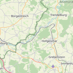
| Centre Point | 51.5903622,9.5331541 |
| OSM | way 76095425 |
| Computed Postcode | 34388 |
| Address Tags | |
| Extra Tags | no (oneway)
asphalt (surface)
3.5 (width)
|
| Local name | Type | OSM | Address rank | Admin level | Distance | |
| Waldstraße | highway:unclassified | way 76095425 | 26 | 0 | details > | |
| Gutsbezirk Reinhardswald | boundary:administrative | relation 1112224 | 16 | 8 | 0 | details > |
| Gieselwerder | place:village | node 874243099 | 16 | 0 | details > | |
| Gottsbüren | place:village | node 31672895 | 16 | 0 | details > | |
| Auf den Gleichen | place:hamlet | node 2199619463 | 16 | 0 | details > | |
| Forsthaus Bensdorf | place:hamlet | node 4540034532 | 16 | 0 | details > | |
| Landkreis Kassel | place:county | relation 62401 | 12 | 6 | 0 | details > |
| Regierungsbezirk Kassel | boundary:administrative | relation 286675 | 10 | 5 | 0 | details > |
| Hessen | place:state | relation 62650 | 8 | 4 | ~1 m | details > |
| 34388 | place:postcode | 5 | 0 | |||
| 34388 | place:postcode | relation 3333236 | 5 | 0 | details > | |
| Deutschland | place:country | relation 51477 | 4 | 2 | 0 | details > |
| de | place:country_code | 4 | 0 | |||
| Europe | place:continent | node 25871341 | 2 | 0 | details > | |
Parent Of | ||||||
Hunting_stand | ||||||
| No Name | amenity:hunting_stand | node 3545500538 | 30 | ~1 km | details > | |