| Name | Bruckmühlweg (name)
|
| Type | highway:track |
| Last Updated | 2018-12-04 10:15 |
| Admin Level | 15 |
| Rank | Street / Major Landmark |
| Importance | 0.1 (estimated) |
| Coverage | Point |
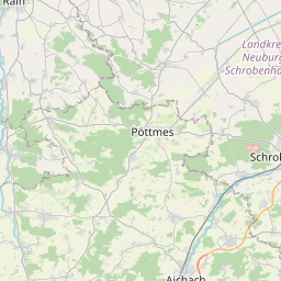
| Centre Point | 48.6907675,10.9874565 |
| OSM | way 95990503 |
| Computed Postcode | 86666 |
| Address Tags | |
| Extra Tags | grade3 (tracktype)
|
| Local name | Type | OSM | Address rank | Admin level | Distance | |
| Bruckmühlweg | highway:track | way 95990503 | 26 | 0 | details > | |
| Burgheim | place:village | relation 943668 | 16 | 8 | 0 | details > |
| Kunding | place:village | node 402281440 | 16 | 0 | details > | |
| Gempfing | place:village | node 29080994 | 16 | 0 | details > | |
| Überacker | place:hamlet | node 29080995 | 16 | 0 | details > | |
| Landkreis Neuburg-Schrobenhausen | boundary:administrative | relation 62655 | 12 | 6 | 0 | details > |
| Obb | boundary:administrative | relation 2145274 | 10 | 5 | 0 | details > |
| Bayern | place:state | relation 2145268 | 8 | 4 | 0 | details > |
| 86666 | place:postcode | 5 | 0 | |||
| 86666 | place:postcode | relation 1142092 | 5 | 0 | details > | |
| Deutschland | place:country | relation 51477 | 4 | 2 | ~3 m | details > |
| de | place:country_code | 4 | 0 |